Drone Mapping Guide
Land surveying has traditionally required survey crews to spend hours collecting measurements across a site. While conventional surveying remains valuable, drone technology has introduced another way to capture detailed information about large areas quickly.
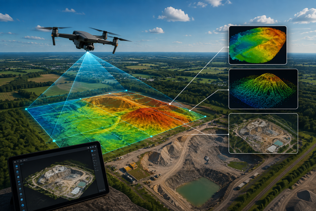
Drone mapping combines unmanned aerial vehicles, high-resolution cameras, positioning systems, and mapping software to create detailed representations of real-world terrain.
For construction companies, engineers, developers, and survey professionals, this technology can provide a faster way to understand site conditions before making important planning decisions.
Companies such as New Jersey Drones are part of a growing industry using drone mapping technology to turn aerial data into useful geospatial information for surveying, planning, and site analysis.
What Is Drone Mapping?
Drone mapping is the process of using an unmanned aircraft to capture aerial images or other sensor data and process that information into accurate digital maps and 3D models.
During a typical project, the drone follows a planned flight path over the area being mapped. Its camera captures multiple overlapping images, which are then processed using specialized photogrammetry software.
Depending on the project, the resulting data can include:
- Orthomosaic maps
- 3D models
- Point clouds
- Digital elevation models
- Digital surface models
- Contour maps
- Topographic information
The important distinction is that drone mapping is not simply aerial photography. The objective is to create measurable spatial data that can be analyzed and used for planning.
How Does Drone Mapping Work?
Although individual projects vary, most drone mapping workflows follow several basic stages.
1. Site Planning
The first step is defining the area that needs to be mapped and determining what information the project requires.
The operator considers:
- Site boundaries
- Required resolution
- Flight altitude
- Ground conditions
- Obstacles
- Weather
- Airspace restrictions
- Required deliverables
2. Automated Flight
The drone follows a predetermined flight path over the site.
Automated missions help maintain consistent altitude, speed, and image overlap, which are important for producing reliable mapping data.
3. Image Collection
The drone captures a series of overlapping aerial photographs.
The overlap allows mapping software to identify common features across multiple images and reconstruct their position in three-dimensional space.
4. Data Processing
The collected images are uploaded into photogrammetry software.
The software aligns the images, identifies matching features, generates a point cloud, and creates mapping products.
5. Quality Control
The final dataset is checked for:
- Coverage gaps
- Blurry images
- Alignment problems
- Positioning errors
- Data inconsistencies
Quality control is important because a beautiful-looking map is not automatically an accurate one. Humans have been fooled by attractive maps since approximately the invention of maps.
Why Are Businesses Using Drone Mapping for Surveying?
The main advantage is the ability to collect a large amount of spatial information efficiently.
Traditional field surveys can require crews to physically access different parts of a site. Drone mapping Guide can capture the same general area from above while reducing the amount of ground travel required.
Faster Site Data Collection
Large areas can often be captured during relatively short flight missions.
Better Site Visualization
Aerial imagery and 3D models provide a visual representation of existing conditions.
Repeatable Surveys
The same area can be mapped repeatedly to monitor changes over time.
Reduced Exposure to Difficult Terrain
Drone data collection can reduce the need for personnel to enter certain difficult or potentially hazardous areas.
Digital Documentation
Survey data can be archived and compared with future datasets.
Drone Mapping vs Traditional Land Surveying
Drone mapping and conventional surveying are not necessarily competing technologies. In many professional workflows, they complement one another.
| Drone Mapping | Traditional Surveying |
|---|---|
| Captures large areas from the air | Collects precise ground measurements |
| Produces aerial imagery and 3D data | Produces detailed point measurements |
| Efficient for site coverage | Excellent for specific control points |
| Useful for repeat monitoring | Useful for legal and engineering surveys |
| Can reduce field exposure | Requires direct field access |
The appropriate method depends on project requirements, accuracy specifications, terrain, and the type of deliverable required.
For projects where detailed aerial context is valuable, drone mapping can complement conventional surveying rather than replace it.
What Can Drone Mapping Be Used For?
Drone mapping has applications across several industries.
Construction
Construction teams can use aerial mapping to document existing site conditions, monitor progress, calculate earthwork quantities, and compare project stages.
Land Development
Developers can use aerial data to understand terrain, drainage patterns, existing features, and site conditions before planning new development.
Mining and Quarrying
Drone mapping can help monitor stockpiles, excavation areas, terrain changes, and site progress.
Agriculture
Agricultural operations can use drone data to analyze field conditions, vegetation, drainage, and other spatial characteristics.
Infrastructure
Roads, bridges, utilities, and other infrastructure can be documented using high-resolution aerial data and 3D models.
Environmental Monitoring
Repeated drone surveys can help organizations observe changes in landscapes, erosion, vegetation, and other environmental features.
What Are the Main Drone Mapping Outputs?
A drone mapping project can generate several different types of geospatial products.
Orthomosaic
An orthomosaic is a geometrically corrected aerial image created by combining multiple photographs.
It provides a map-like view of the surveyed area.
Point Cloud
A point cloud is a collection of millions of points representing the three-dimensional structure of the environment.
Digital Elevation Model
A DEM represents elevation information and can be used for terrain analysis.
Digital Surface Model
A DSM represents the elevation of the Earth’s surface along with objects such as buildings and vegetation.
3D Model
A 3D model provides a visual representation of the surveyed environment and can be useful for visualization, inspection, and planning.
What Factors Affect Drone Mapping Accuracy?
Drone mapping accuracy depends on the complete workflow rather than just the drone.
Important factors include:
- Camera quality
- Flight altitude
- Image overlap
- GPS positioning
- RTK or PPK technology
- Ground Control Points
- Weather
- Lighting
- Terrain
- Processing software
- Quality control
For projects requiring survey-grade results, appropriate ground control and positioning methods may be necessary.
The project should always define its required accuracy before the flight begins.
When Should You Use Drone Mapping?
Drone mapping can be particularly useful when a project requires:
- Large-area aerial coverage
- Frequent site updates
- Detailed visual documentation
- 3D terrain information
- Construction progress monitoring
- Stockpile measurements
- Site planning
- Topographic information
- Digital site records
It may not be the best standalone solution for every surveying task. Legal boundary surveys, highly precise engineering measurements, and certain specialized applications may still require conventional surveying techniques.
The strongest workflows often combine drone data with established surveying and GIS methods.
How to Get Better Results From a Drone Mapping Project
A successful mapping project starts before the drone takes off.
Define the Deliverable
Know whether the project requires an orthomosaic, point cloud, elevation model, 3D model, or another product.
Plan the Flight Carefully
Choose an appropriate altitude, flight path, image overlap, and survey boundary.
Check Weather Conditions
Wind, rain, shadows, and changing lighting conditions can affect data collection.
Use Appropriate Positioning
GPS, RTK, PPK, and ground control points can improve positional accuracy when required.
Verify the Data
Review the captured imagery before leaving the site. Discovering missing coverage after returning to the office is a remarkably efficient way to waste an afternoon.
Maintain Consistency
For repeat surveys, use consistent flight parameters and workflows so datasets can be compared more reliably.
The Future of Drone Mapping
Drone mapping is becoming increasingly connected with other geospatial technologies.
Modern workflows can combine:
- Photogrammetry
- LiDAR
- RTK positioning
- GIS
- Artificial intelligence
- 3D modeling
- Digital twins
- Cloud-based processing
This combination allows organizations to move beyond simple aerial imagery toward detailed digital representations of real-world environments.
As processing software and autonomous flight systems continue to improve, drone mapping is likely to become an increasingly common component of surveying, construction, infrastructure, and environmental workflows.
Final Thoughts
Drone mapping has changed how many organizations collect and understand spatial information. Instead of relying exclusively on ground-based measurements, teams can capture detailed aerial datasets and transform them into orthomosaics, point clouds, elevation models, and 3D representations.
The technology is particularly valuable for projects involving large areas, repeated surveys, difficult terrain, construction monitoring, land development, mining, and site planning.
However, successful drone mapping is about more than simply flying a drone. Careful mission planning, suitable sensors, accurate positioning, reliable processing, and quality control all contribute to useful results.
For readers looking for a deeper explanation of drone mapping workflows, software, accuracy, applications, and best practices, the New Jersey Drones Drone Mapping Guide provides a comprehensive resource covering the technology in greater detail.