I will always cherish the trek to Mahuli. The Mahuli fort is located on a single hill on Shahapur’s western face, while the major Sahyadri range is located on the city’s eastern side. My first walk in my life, the one that took me to Mahuli, is still very much in my recollection today.
A select group of pals who were all passionate about trekking visited Mahuli Fort in the Shahapur area. I’ve always had a special place in my heart for the Mahuli trek. It’s my favorite trek, according to some.
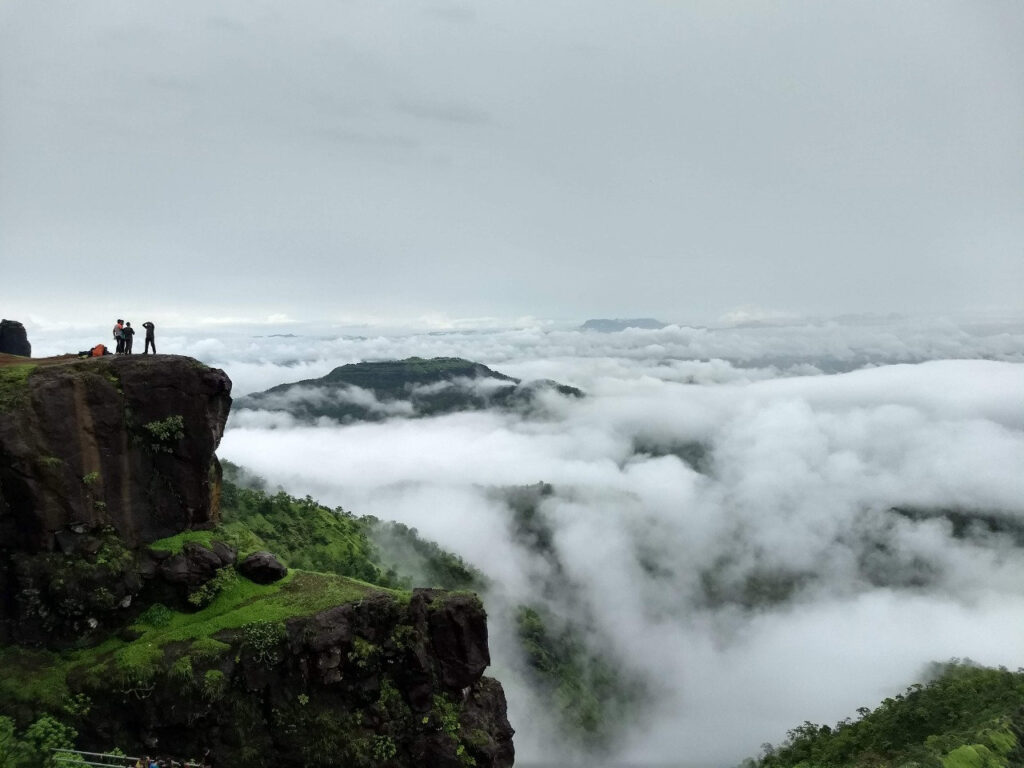
The Mahuli Fort
Mahuli, at 2815 feet above sea level, is a good one-day walk close to Mumbai. It is Thane district’s highest point. Its pinnacles make it a popular trekking destination and a rock climber’s heaven.
In reality, this mountain complex is a collection of two or more hills that share pinnacles and Cols. A sanctuary has been established over the woodland that encircles Mahuli. The Archaeology Survey of India has designated Mahuli Fort as a protected monument.
Details of the Mahuli Fort Trek
The Mahuli Fort Trek has a medium level of difficulty and requires a lot of endurance. There is water available in the base settlement, and there is a tiny, permanent drinking water cistern above it. Add the following choices to this trek:
Pinnacles in Vorpadi, Ajoba Hill, and Sitecha Palna. June through December is the ideal time of year to trek Mahuli. Availability of food Order from the villager and then come back to savor the treat. Mahuli Village is the base village. There is now camping close to Mahuli Fort’s base settlement.
Pinnacles of Mahuli
The three connected forts on top of the massive Mahuli hill are seen directly in front. Mahuli Chanderi, also known as Bhandargad, is the fort on the left. Mahuli is in the middle, while Chota Mahuli is on the left. The well-known pinnacles of Navra, Navri, and Karavali are situated between the Bhandargad and Mahuli.
If the goal is to reach Chota Mahuli, a one-day trek to Mahuli can be undertaken. However, you will need to spend the night in the caverns if you want to cover the entire slope, including the pinnacles. There is enough for about 12 people in the caves.
a 45-minute hike from Chota Mahuli across the plateau. After roughly 20 feet of rock climbing, you have to ascend another iron ladder. After that, a 25-minute one-way trek will provide you with an excellent perspective of the three pinnacles.
Mahuli Killa’s history
This fort was built by the Mughals. A few architectural designs that are now in ruins can be used to draw conclusions. The Nizam Shahi dynasty ruled this fort. This fort was taken from the Mughals by Shivaji Maharaj.
The Marathas lost the fort once more in the Purandar Treaty. Shivaji Maharaj made an unsuccessful attempt to subjugate Mahuli. They murdered a thousand Marathas. They were mostly from neighboring communities. “He is our gold,” Shivaji Raje told his deceased Kadam Sardar. Raje therefore gave this family the surname “Sonare.”
Shivaji Raje offered 22 forts as a truce in one such arrangement. Three of them were the ones listed above. However, even if the names are different, there is one big unconfirmed fort. Prior to Raigad, Mahuli was one of Shivaji Raje’s first capitals.
Trekking to Mahuli Fort near Mumbai
Arrive in Asangaon, then travel to the base village via local ST bus. Additionally, there is an auto option. Leave the approach road. There is an inroad to Mahuli just past the Hanuman temple. The start of the walk is also marked by a little board. There is a clearly indicated path to the top.
Some people think it climbs gradually. There are a couple hard grade rises on this walk as well. You will reach a plateau after about 90 minutes of hiking, where you will find the iron ladder. Chota Mahuli is an hour’s hike away.
Attractions at Mahuli Fort
- Shivling in the open
- The biggest of the three caves is suitable for an overnight stay.
- The ‘Kalyan Darwaja’ is a stone arch that has historical significance. The arch’s dome is now broken.
- It takes ten minutes to walk from Chota Mahuli to the “Namazgir” wall, which is thought to be a Muslim place of devotion.
- There are old home and stable ruins visible.
- A lovely view of Tansa Lake.
- Here, Kalyan Darwaja rock climbing skills will be necessary. Water is stored in a tank all year round.
Information about Mahuli Fort
- Mahuli Killa 2815 feet in height
- Mahuli Killa Asangaon is the nearest train station.
- Mahuli Base Village is around 135 kilometers from Pune. Three hours of driving time.
- About 70 kilometers separate Mumbai and Mahuli Base. About 1 hour and 45 minutes was spent driving.
- Manas Mandir is a landmark on the Nasik Highway. From there, one can go straight to Mahuli Village. At a junction, do not turn right for Manas Mandir.
Important Information, Mahuli
The fort is surrounded by dense foliage, and it is frequently possible to glimpse wild animals there. In the past, trekking activities have been restricted here due to leopard sightings. During the monsoon, wild flowers will give you a warm greeting.
Please use the information above solely as a guide. Before you go, please consult professionals. Additionally, off-late water fall rappelling has been planned. Please stay away from Waterfall near Mahuli Fort during the monsoon season as there have been numerous deadly occurrences there.