Drone 3D Scanning
Stockpiles are everywhere in industries that handle large quantities of materials. Construction companies, quarries, mines, aggregate suppliers, and material yards all need to know how much material is sitting on the ground.
The problem is that measuring a large stockpile manually can be slow, difficult, and sometimes unsafe.
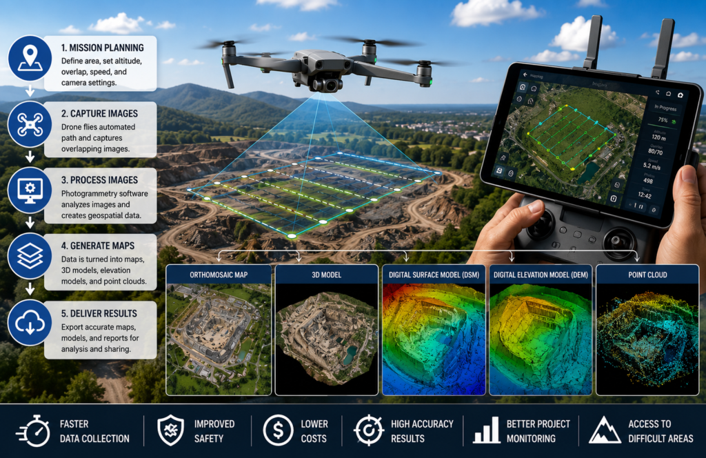
This is where drone 3D scanning for stockpile measurement becomes useful. A drone equipped with photogrammetry or LiDAR sensors can capture detailed aerial data and turn it into a three-dimensional representation of the stockpile. From that model, software can calculate volume, surface area, elevation, and other measurements.
Instead of relying on a few manual measurements and mathematical assumptions, project teams can work from a detailed digital model of the actual site.
What Is Drone Stockpile Measurement?
Drone stockpile measurement is the process of using a UAV equipped with a camera, LiDAR sensor, or both to capture data over a material stockpile and calculate its dimensions and volume.
The drone collects overlapping aerial imagery or laser measurements while following a planned flight path. Specialized processing software then converts the captured data into a 3D model or point cloud.
From this data, professionals can calculate:
- Stockpile volume
- Surface area
- Maximum elevation
- Stockpile footprint
- Cut-and-fill quantities
- Material changes over time
This approach is particularly useful when a site contains multiple stockpiles or covers a large area.
Why Are Stockpile Measurements Important?
Knowing the approximate quantity of material on-site is important for much more than record keeping.
Accurate volume information can support:
- Inventory management
- Material purchasing
- Production planning
- Financial reporting
- Project estimating
- Mining operations
- Quarry management
- Construction planning
- Progress monitoring
For example, an aggregate company may need to know how much material is available before scheduling deliveries or planning additional production.
If measurements are inaccurate, the resulting inventory calculations can also be inaccurate. Humans have somehow spent centuries finding increasingly complicated ways to miscount piles of rocks, so better data is useful.
How Does Drone Stockpile Measurement Work?
A typical drone stockpile survey follows several stages.
1. Site and Mission Planning
The first step is defining the area that needs to be surveyed.
The operator considers:
- Stockpile locations
- Site boundaries
- Required accuracy
- Flight altitude
- Ground conditions
- Obstacles
- Airspace restrictions
- Weather conditions
The flight should be planned so the drone captures sufficient coverage of the entire stockpile and surrounding ground.
2. Capturing Aerial Data
The drone follows a planned flight path while collecting photographs or LiDAR measurements.
With photogrammetry, the camera captures a large number of overlapping images. Software later identifies common features between those images.
With LiDAR, the sensor sends laser pulses toward the ground and measures their returns to create spatial information.
The choice between the two depends on project requirements, terrain, vegetation, desired detail, and accuracy requirements.
3. Creating a 3D Point Cloud
After the flight, the collected data is processed into a point cloud.
A point cloud consists of thousands or millions of individual points representing locations in three-dimensional space.
For a stockpile, these points can represent:
- Material surface
- Ground around the pile
- Stockpile edges
- Terrain elevation
- Nearby structures
The result is essentially a digital representation of the site.
4. Creating a Surface Model
The point cloud can then be used to generate a surface model representing the stockpile.
The software identifies the boundaries and elevation changes across the pile.
Depending on the workflow, the resulting data may include:
- 3D mesh
- Digital Surface Model
- Digital Elevation Model
- Contours
- Orthomosaic
- Point cloud
The surface model provides the foundation for calculating the stockpile’s volume.
How Is Stockpile Volume Calculated From Drone Data?
Volume calculation generally requires comparing the stockpile surface with a defined base or reference surface.
The software analyzes the difference between these surfaces and calculates the volume between them.
A simplified concept looks like this:
Stockpile Volume = Material Surface − Reference/Base Surface
In a real project, the calculation can involve thousands or millions of elevation measurements rather than a few manual dimensions.
This makes the method particularly useful for irregularly shaped stockpiles where traditional geometric formulas may not represent the actual shape very well.
Drone Stockpile Measurement vs Manual Measurement
Drone surveying and traditional measurement methods each have their place, but they work very differently.
| Factor | Drone Measurement | Manual Measurement |
|---|---|---|
| Area Coverage | Large areas quickly | More limited |
| Data Collection | Aerial | Ground-based |
| 3D Model | Yes | Usually limited |
| Repeat Surveys | Easy to schedule | More labor intensive |
| Site Access | Can reduce ground exposure | Requires field access |
| Volume Analysis | Software-based | Often manually calculated |
| Documentation | Digital record | Field notes/surveys |
For small and simple stockpiles, traditional methods may still be practical. For large sites with multiple piles, frequent measurements, or difficult terrain, drone-based data collection can offer significant operational advantages.
Photogrammetry vs LiDAR for Stockpile Surveys
Both technologies can be used for stockpile mapping, but they collect information differently.
Photogrammetry
Photogrammetry uses overlapping photographs to reconstruct three-dimensional geometry.
It can be a strong choice when the project requires:
- High visual detail
- Orthomosaic imagery
- 3D textured models
- Cost-effective aerial data collection
LiDAR
LiDAR uses laser measurements to capture three-dimensional spatial information.
It can be particularly useful when:
- Terrain is complex
- Vegetation is present
- Dense point clouds are required
- Detailed elevation information is important
The best technology depends on the site and project requirements rather than a simple “one is always better” rule.
For a broader explanation of the technologies, workflows, accuracy considerations, and deliverables involved, a detailed drone 3D scanning guide can provide useful background.
How Accurate Is Drone Stockpile Measurement?
Accuracy depends on much more than the drone itself.
Important factors include:
- Sensor quality
- Flight altitude
- Image overlap
- GNSS positioning
- RTK or PPK capability
- Ground control points
- Ground conditions
- Weather
- Processing software
- Quality of the reference surface
A carefully planned survey can produce highly detailed measurements, but accuracy should always be evaluated against the requirements of the specific project.
For high-value inventory or engineering decisions, an independent accuracy assessment may also be appropriate.
How Often Should Stockpiles Be Measured?
There is no universal schedule.
The right frequency depends on how quickly material moves through the site.
Low-Activity Sites
Monthly or quarterly surveys may be sufficient.
Active Construction Sites
Weekly or biweekly measurements can provide better visibility into material movement.
High-Volume Mining and Aggregate Operations
More frequent surveys may be valuable when stockpile quantities change rapidly.
Regular drone surveys also create a historical record, allowing teams to compare stockpile conditions over time.
Benefits of Drone Stockpile Measurement
Faster Data Collection
Large areas can be captured without sending multiple survey crews across the site.
Safer Operations
Drone surveys can reduce the need for personnel to physically climb or approach unstable stockpiles.
Detailed Digital Records
Each survey can create a digital record that can be archived and compared with previous surveys.
Better Inventory Management
Updated volume information helps teams understand how much material is available.
Easier Change Detection
Repeated surveys allow businesses to identify where material has been added, removed, or relocated.
Better Project Decisions
Current spatial data gives managers a clearer picture of actual site conditions.
Industries That Use Drone Stockpile Surveys
Mining
Mining operations can use drone surveys to monitor extracted material, waste piles, and active work areas.
Quarries
Aggregate producers can measure large quantities of crushed stone, gravel, sand, and other materials.
Construction
Construction companies can monitor fill material, excavated soil, and temporary stockpiles.
Landfills
Drone mapping can support volume calculations and ongoing site monitoring.
Recycling Facilities
Material yards can use 3D surveys to monitor changing inventory levels across large storage areas.
Agriculture
Certain agricultural operations may use aerial mapping to measure stored soil, compost, mulch, or other bulk materials.
Common Challenges in Drone Stockpile Surveys
Drone technology does not magically eliminate every problem. Sadly, physics remains employed.
Poor Weather
Strong wind, rain, or low visibility can affect data collection.
Stockpile Movement
If material is being moved during the survey, the site may change between flights.
Poor Ground Definition
Accurately identifying the base of a stockpile can be challenging when piles overlap or sit on uneven terrain.
Vegetation
Grass or vegetation around a stockpile can complicate surface identification.
Reflective Materials
Certain surfaces can create challenges for optical sensors and photogrammetry workflows.
Insufficient Image Overlap
Poor overlap can create gaps or reconstruction problems in photogrammetric datasets.
Best Practices for Accurate Drone Stockpile Measurement
Before starting a survey, operators should:
- Define the survey boundary.
- Inspect the site for obstacles.
- Plan an appropriate flight altitude.
- Maintain sufficient image overlap.
- Use suitable positioning technology.
- Consider GCPs when project accuracy requires them.
- Capture the complete stockpile and surrounding reference area.
- Review the collected data before leaving the site.
- Process the dataset using appropriate software.
- Document the measurement methodology and results.
Consistency is especially important when surveys will be repeated over weeks or months.
What Deliverables Can You Get From a Drone Stockpile Survey?
Depending on the project, a drone survey may produce:
- Point clouds
- 3D models
- Orthomosaic imagery
- DSMs
- DEMs
- Contour maps
- Elevation data
- Stockpile volume reports
- Surface area calculations
- Cut-and-fill analysis
The most useful deliverable depends on what the client actually needs to do with the data.
A quarry manager may primarily need volume reports, while an engineering team may also require point clouds and CAD-compatible data.
Final Thoughts
Drone 3D scanning provides a practical way to turn stockpiles into measurable digital data. Instead of relying entirely on manual measurements, businesses can capture detailed aerial information, generate 3D surface models, calculate material volumes, and compare site conditions over time.
The technology is particularly valuable for mining, quarrying, construction, aggregates, recycling, and other industries where material quantities change frequently. Accurate results depend on proper mission planning, sensor selection, positioning, data processing, and quality control.
Companies exploring professional drone-based surveying and 3D data collection can also work with experienced providers such as Drone As A Service, which offers drone technology solutions for mapping, surveying, 3D scanning, and other geospatial applications.
Ultimately, the value of drone stockpile measurement is not simply the ability to capture aerial imagery. It is the ability to turn that imagery into reliable measurements and actionable 3D data that can support better planning, inventory management, and operational decisions.